
Katherine Gorge Canoeing
Smitt Rock, a large rocky island in the middle of the gorge.
Katherine Gorge; Nitmiluk National Park; Canoeing Guide; Barrak Barrak
It was possible to canoe from the boat ramp located near the Nitmiluk Information centre in earlier years. However, the ever-increasing threat of saltwater crocodiles has put heed to this. Today you are obliged to travel on the ferry to the start of the second gorge before starting your canoe trip. In itself, the boat ride is a great way to sit back and enjoy the grandeur of the gorge, the guides on the boat are always keen to stop and point out local highlights and wildlife along the way. Note various gorge boat tours are available that may extend up to the third gorge. This boat trip takes you 3.2km up the first gorge to the start of the second gorge. The rocky section that marks the beginning of the second gorge has Jawoyn Art Sites that must be viewed.

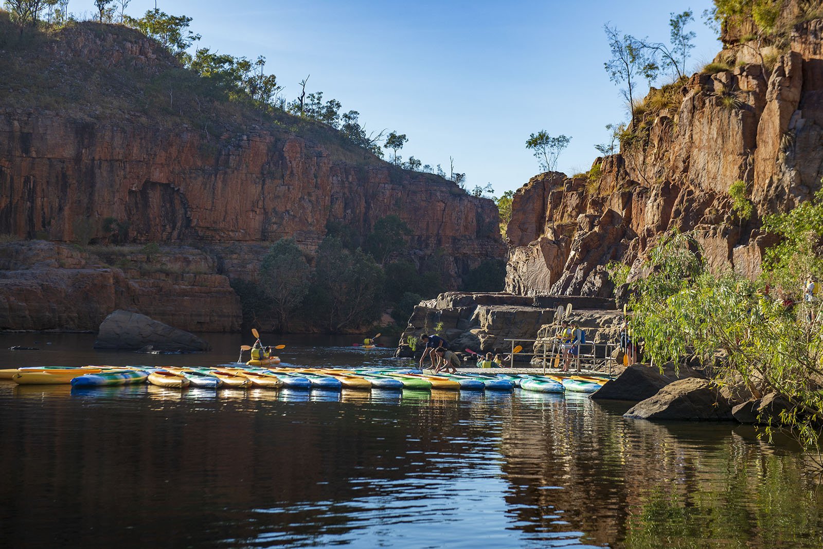
A short walk over the rocky section between the first and the second gorge gets you the first glimpse of the canoes (Kayaks). About 50 to 80 canoes on their moorings mark the start of the second gorge. The canoeists leave in groups, with the first to go being the half-day canoeists (Malappar Traveller) followed by the whole day canoeists (Kuluyampi Explorer), and last to leave are the people who are doing the two-day overnight trip (Barrak Barrak). We fall into the latter group and watch all the canoeists go before we load up our gear into the canoes. We take two double canoes and a single canoe. The double canoe is the Australis 2 Up canoe that weighs 26kg and is 4m long. The single canoe weighs 18 kg and is 2.8 m long. Keep this in mind; you will be required to either pull or carry these canoes up and over the rapids as you progress up the gorges. These canoes get wet, so make sure all the gear you take is within a watertight container. We have two large bags and place them between the paddlers in the double canoes. However, this is not a great spot to store luggage as it interferes with the back paddler's leg space and ability to paddle. Try to divide your luggage into two smaller bags that will fit into the front and back compartments in the canoe. An estimation of the size of these forward and aft compartments would be about 30 cm deep, 70 cm wide and about 50 cm long. A word of advice, pack light as all additional weight needs to be paddled and hauled over the rocky areas between the gorges. In addition, no camping is allowed in the first three gorges, and you need to get to at least the fourth gorge before you can set up a camp.
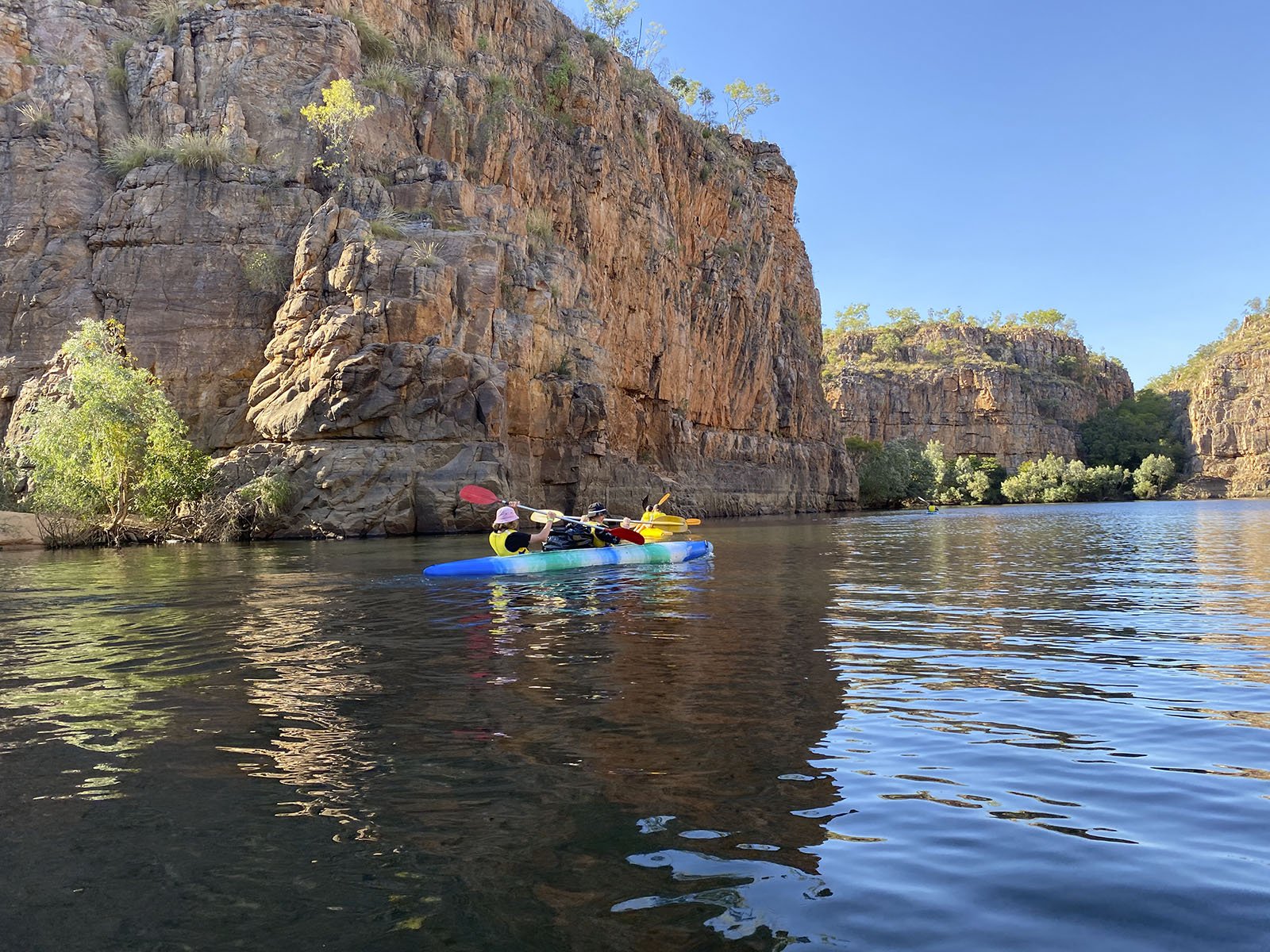


The second gorge represents the most extended section of continuous paddling with a distance of about 2.4 km and an estimated paddling time of 50 min. The first half of the second gorge hides its secrets well with a series of three right-angle turns limiting your view of what is to come. As you take the turn into the last section, the sheer cliff walls on either side of the gorge tower above you and a straight run of about one km lies ahead. To the south of this bend is Butterfly Gorge, with a walk up the gorge into a rainforest. This corner also represents a 30-meter-deep section where Bolung, the Rainbow Serpent, is said to live.


The transition from the second to the third gorge (5 min) is a relatively flat, short section of rocky rapids that the canoes need to be pulled over before you can start the third gorge. Moorings for the boats that do the gorge tours are located on the northern shore at the end of the second gorge. The third gorge is relatively short, being about 1km long with an estimated paddling time of 25 min. On the north shore shortly before Golden Gorge are Jawoyn Art Sites that can be explored. The southern bank holds a vast gorge, and early in the dry season, a short walk takes you to a waterfall with a deep swimming hole below it, Lilli Ponds.
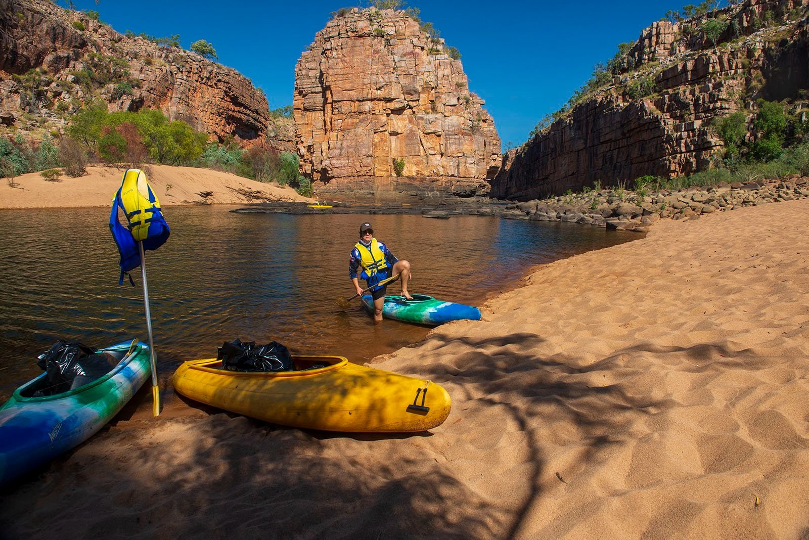


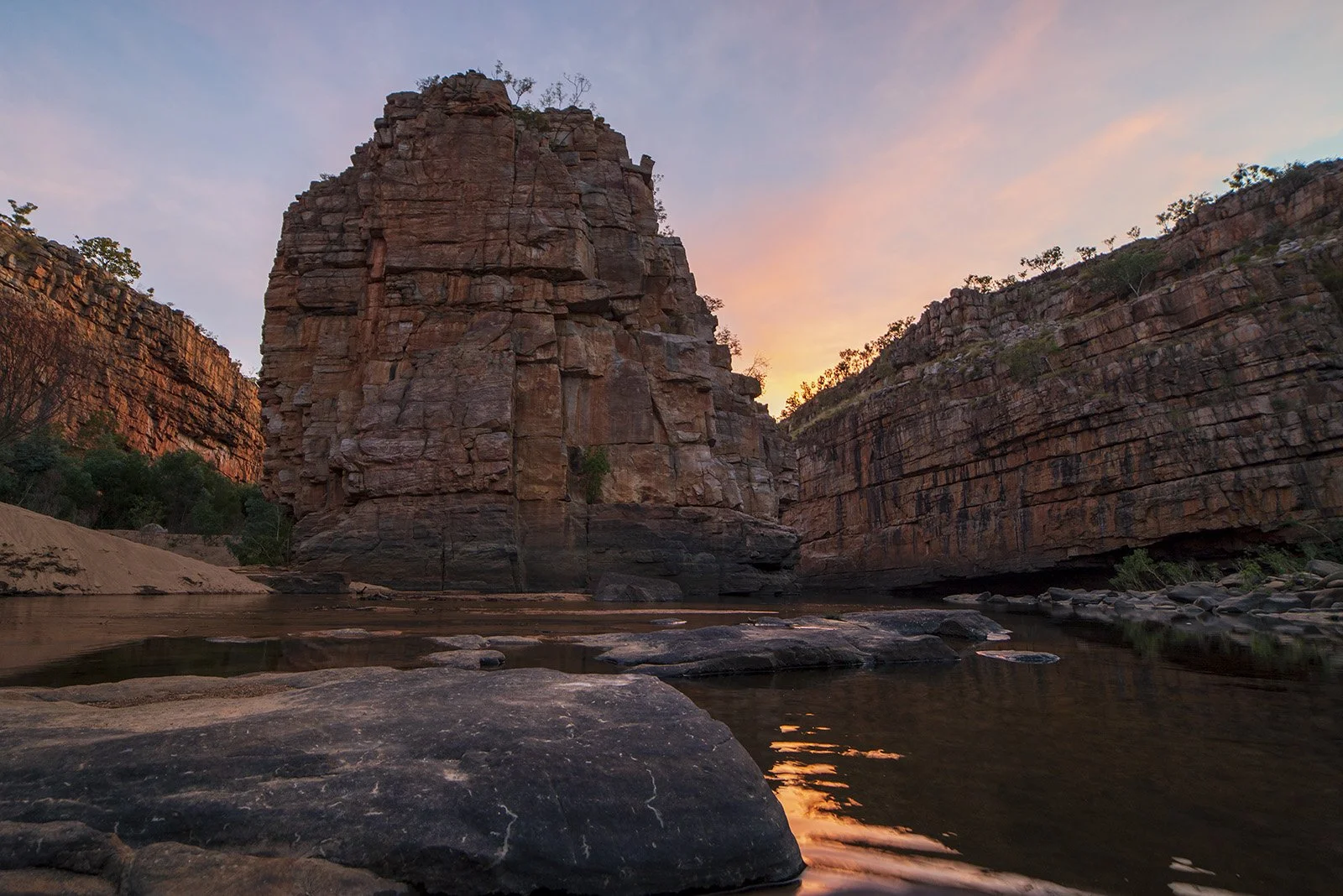
The transition from the third to the fourth gorge (40 min) consists of several rocky rapids with a short paddle between each of these sections extending over a distance of some 800m. The fourth gorge is about 1.4 km long, with only about 700m that you can paddle. Soon after the rapids, you reach Smitt Rock, a large rocky island in the middle of the gorge. The island is about 200m long and 40 m wide, with towering cliffs equal to the gorge wall in height. The rounded upstream point of this island is iconic and makes for great photos in both early morning and late afternoon light. The section near the head of Smitt Rock is shallow again, with canoes needing to be hauled over this short section. Immediately after crossing the rocky bar, a sandy beach is seen on the north shore. This beach is the first site where canoeists can camp overnight. A composting toilet was available towards the back of this beach. The toilet has been damaged in floods and was not usable in 2021. A second designated camping area on the southern bank between Smitt Rock and the gorge wall is reserved for hikers on the southern walks. If you wish to walk out the gorge, then walking track indicators (the typical reflective triangles) can be found on the south of the gorge wall next to Smitt Rock. These indicators direct walkers downstream between the gorge wall and Smitts Rock before coming around and ascending the gorge. This ascent is a steep rocky walk ( 20 to 30 min) that takes you out the canyon to an ECD (emergency contact device) as well as a composting toilet for hikers.


The transition from the fourth to the fifth gorge has several sections of rocky rapids towards its end, with an approximate time to transit each of the three rapids being 10 min, 20 min and 20 min. The fifth gorge is a long paddle of 1.6 km. This gorge is a narrow, deep gorge that is very scenic.
The transition from the fifth to the sixth gorge (30 min) is a steep low waterfall and a short section of rocky rapids that the canoes need to be pulled over before you can start the sixth gorge. Shortly after entering the sixth gorge, you find the next camping beach for canoeists. The camping area presents as a steep sandy beach that flattens on the top to provide a good camping area. If you walk back into the gorge about 80m, you will find a seasonal waterfall and a small swimming hole. This site has a composting toilet. This gorge is 1.6 km long and should take 15 min of paddling.


The transition from the sixth to the seventh gorge (40 min) is a difficult transition consisting of five sections of rocky rapids with a short paddle between each of these sections extending over a distance of some 500m. The seventh gorge is a short gorge of only 400m that should take 5 min to paddle.
The transition from the seventh to the eighth gorge is complex (20 min). This transition is short, but the river narrows into a deep section with low waterfalls surrounded by large rocks. We got the first canoes up the river but opted to carry the remaining canoes overland, not easily achieved due to the steep inclines. The eighth gorge now lies in front of you, the northern side of the canyon opens up, and a large sandy beach is on the north shore. The southern gorge wall is steep, high and dominated by a large black area designating a huge seasonal waterfall that must look spectacular in the wet season. The gorge makes a 90-degree bend at this point, and the southern bank dominates your view as you paddle the initial section of this gorge. To the north of the waterfall is a tree-lined shady beach that is the designated campsite for hikers who undertake the southern walks to the eighth gorge. A short steep walk from this campsite will, however, get you to an ECD (emergency contact device) as well as a composting toilet for hikers. This gorge is a short paddle of 600m should take about 10 min.


The transition from the eighth to the ninth gorge (30 min) is up a fast running, narrow section with low waterfalls and about 50m long. Huge round rocks dominate this transition and make it impossible to carry the canoes overland. Getting the canoes up the fast-running water was difficult and would have been very difficult without a 5m rope to help pull the canoes over the rapids. Even with the three of us and the rope, we still managed to capsize one of the canoes. Getting the water out of the canoe and back up the transition was difficult. However, once you are in the ninth gorge, you enter an area where very few paddlers venture. This gorge is magnificent, with narrow, steep walls and deep quiet waters. The canyon has a large sandy beach on the "southern" bank designated as the campsite for canoeists in the ninth gorge. When we explored the beach campsite, it did not show any evidence of people being there for some time. This campsite has no toilet facilities. If you venture to the end of the ninth gorge, your passage is blocked with large, high boulders. No water flows over these rocks; however, the water does flow under them. Canoeists are only allowed to this point. Special permits are required to explore the remaining gorges. However, getting the canoes over the enormous boulders between the ninth and the tenth gorge would be difficult.


We overnighted at the campsite in the sixth gorge. Most of the day, canoeists do not venture up this far, and even in peak season, only the occasional canoeist was seen from the sixth gorge upwards. We paddle up to the ninth gorge the next day and found a group of hikers swimming in the eighth gorge. Make no mistake paddling the canoes is the easy part. Hauling the canoes over the rapids is hard work, and the further you go, the harder it gets. It is advised that a high level of fitness is required to get to the sixth gorge, a distance of 6.4 km from the start of the second gorge. If you think of overnighting in the ninth gorge, be prepared for a long hard physical day on the water. From the sixth gorge campsite it is an additional 2.5 km before you get to the camp in the ninth gorge. In addition, the transitions between the gorges are much harder from the sixth gorge onwards.
We packed a camping stove, as no open fires are allowed, tent/mosquito dome, sleeping bags, torch, sleeping mats, suntan lotion, mosquito replant and food. We used water from the river purified or boiled before use, and we all seemed to do well on this. Making an overnight trip does afford you the time to explore some of the gorges and waterholes that run into the main canyon, have a swim and have light lunch on a secluded beach. As a photographer, the only way to experience the late afternoon and early morning light in the gorge is by undertaking an overnight canoe trip. As an additional bonus, you get to experience the peace and tranquillity of the canyon at night under a starry sky.
What would I do differently? Take less within the canoe to travel as light as possible. I would probably ditch the tent and mattress as the beach sand was quite comfortable, and we encountered very few problems with mosquitoes. I would undoubtedly take a fishing rod as the upper gorges look like prime spots to fish. No bait fishing is allowed, and only lures are to be used. The target species would be Sooty Grunter (Hephaestus fuliginosus), also known as Black Bream, although the occasional Barramundi may present itself.
This is a great outing and is highly recommended.


